乙支路洞
乙支路洞(:/ Euljiro dong */?),是大韩民国首尔特别市中区北部一个的行政洞。[1],2013年人口1,947。
| 乙支路洞 | |
|---|---|
| 韓文名稱轉寫 | |
| • 韓字 | |
| • 漢字 | |
| • 文化觀光部2000年式 | |
| • 馬科恩-賴肖爾表記法 | |
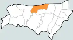 | |
| 坐标:37°33′50″N 126°59′45″E | |
| 國家 | |
| • 下轄行政區 | 10个法定洞 |
| 面积 | |
| • 总计 | 0.60 平方公里(0.23 平方英里) |
| 人口(2013)[1] | |
| • 總計 | 1,947人 |
| • 密度 | 3,200人/平方公里(8,000人/平方英里) |
参考文献
- . [2008-05-01]. (原始内容存档于2016-04-06) (韩语).
This article is issued from Wikipedia. The text is licensed under Creative Commons - Attribution - Sharealike. Additional terms may apply for the media files.