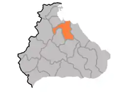
安邊郡
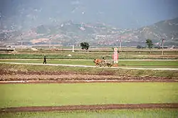
安邊郡(:/ Anbyŏn gun */?)是朝鮮民主主義人民共和國江原道北部的一個郡,北臨海,西靠馬息嶺山脈,東枕太白山脈,南大川流貫其中,形成了朝鮮半島東岸少見的平原——安邊平原。下分1邑、2勞動者區、28里。
| 安邊郡 | |
|---|---|
| 郡 | |
| 朝鮮文名稱轉寫 | |
| • 韓字 | |
| • 漢字 | |
| • 文化觀光部2000年式 | |
| • 馬科恩-賴肖爾表記法 | |
 | |
 | |
| 坐标:39°02′N 127°30′E | |
| 國家 | |
| • 下轄行政區 | 1 邑、2勞動者區、28里 |
1018年起稱安邊。原為咸鏡南道一部份,1946年歸江原道,江原線經過,當地並設有旗杆岭导弹基地(参见2006年北韓導彈試驗)。
This article is issued from Wikipedia. The text is licensed under Creative Commons - Attribution - Sharealike. Additional terms may apply for the media files.