2009年澳大利亚沙尘暴
2009年澳大利亚沙尘暴于2009年9月22日-24日席卷澳大利亚东部,是纽省70年来最大的一场沙尘暴。最严重时沙带长超过2500公里。纽省、昆省和维省许多城镇都被橘红色或昏黄色的沙尘所笼罩。据预测有数百万吨的沙尘在此次沙尘暴中被转移。
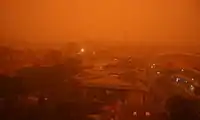
摄于 2009年9月23日早6:20 的悉尼。
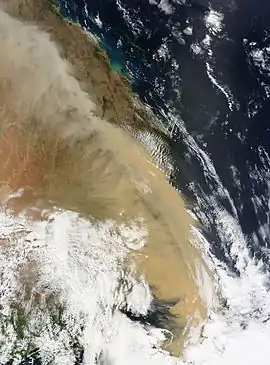 由大地衛星所拍攝的MODIS,
2009年9月23日拍攝的澳大利亞東部地區沙塵暴衛星空拍圖。 | |
| 形成 | 2009年9月22日 |
|---|---|
| 消散 | 2009年9月24日 |
| 損失 | 無 |
| 死亡 | 無 |
| 影響地區 | |
9月22日下午,一 股在纽省西部上空的强冷风,导致雷暴、大风天气。大风从干旱的澳洲内陆地区带来大量的沙尘,迅速向东北方移动。这股沙尘于22日下午 3:30 袭击布罗肯山(Broken Hill),导致天空顷刻之间变为黑色。23日凌晨到达堪培拉,并于此后到达悉尼和布里斯本。悉尼的沙尘暴在23日下午逐渐散去。
外部連結
![]() 維基共享資源中与2009年澳大利亚沙尘暴相關的分類
維基共享資源中与2009年澳大利亚沙尘暴相關的分類
- Dust storm in Australia页面存档备份,存于 at The Big Picture
- Some photographs from smh.com页面存档备份,存于
- In pictures: dust storm in Australia页面存档备份,存于 at The Daily Telegraph
- Dust over Eastern Australia页面存档备份,存于 at Earth Observatory (part of the NASA EOS Project Science Office)
- New South Wales Government – Department of Environment Climate Change and Water (EPA)Archived 2009-09-29 at WebCite – Hourly Air quality index (AQI) values (Current and Historical) with map
- Queensland Government – Environment and Resource Management – Hourly Air Quality Data页面存档备份,存于 (Current and Historical)
- DustWatch interactive dust map viewer
| 维基共享资源中相关的多媒体资源:2009年澳大利亚沙尘暴 |
This article is issued from Wikipedia. The text is licensed under Creative Commons - Attribution - Sharealike. Additional terms may apply for the media files.